 New releases New releases |
| Leica Viva GS08/12 released in China market |
| → More |
| Leica phone measurement system V2.0 released in China |
| → More |
| Leica TS11 & 15 next generation high-precision total stations |
| → More |
|
|
|
|
|
| |
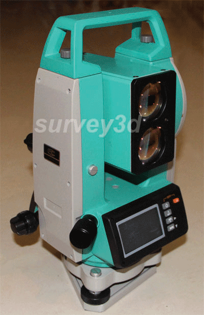
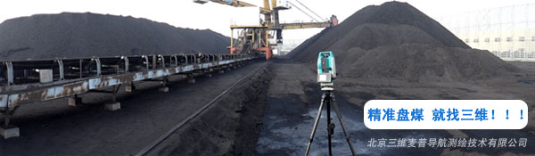
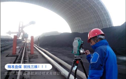
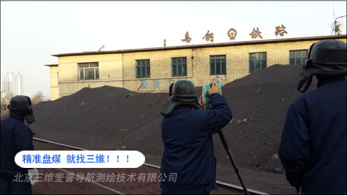
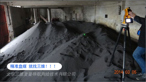
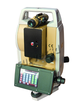
SW-31 Laser-based coalpile-inventorying instrument
|
%20-%20Leica%20Geosystems%20-%20Leica%20Geosystems.files/pix.gif) |
|
|
|
|
| 产品名: |
Laser-based coalpile-inventorying instrument 回中文
|
| 型 号: |
SW-31-type disc coal total station |
| 品 牌: |
survey |
| 报 价: |
|
| 下 载: |
PDF Download |
|
|
|
INSTRUMENT DESCRIPTION |
|
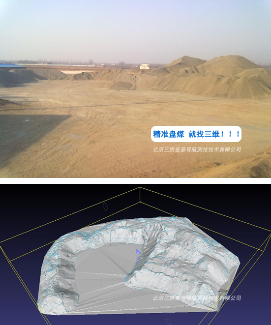
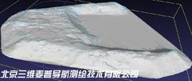
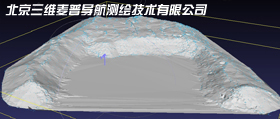
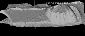
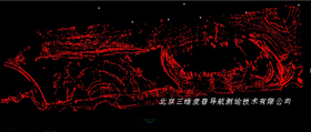
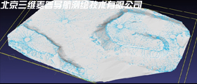
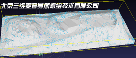
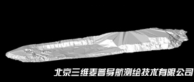
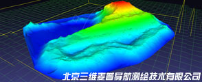
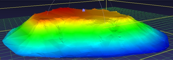
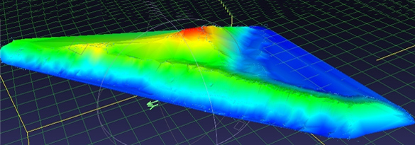
From the professional point of the scientific method to solve problems pile volume measurement
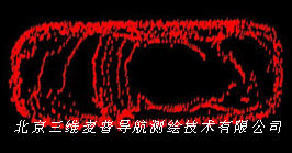
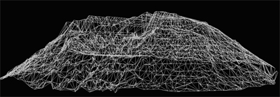
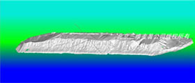
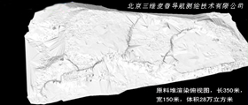
??? SW31 is the latest development of the three-dimensional laser scanning system that can be applied to the measurement of inventories of materials and Other 3D scanning applications. The whole system mainly consists of high precision angle measurement system and laser rangefinder components.
This product uses the latest laser measurement technology, the largest measuring range 1,700 meters (na-tural reflex target 500 m), fine Less than 2 cm, the measurement speed up to 10 points / sec; using high-precision optical encoder for angle measurement, high accuracy Up to 2 seconds, without environmental impact; instrument semiautomatic work, the work can be done only manually rotate the telescope automatically sweep Scan, the scan data directly into the memory; The system uses a specialized three-dimensional model-ing software, powerful, direct-Read memory scanning point data, generate DTM model; calculate volume, area, and other spatial data information; instrument body Plot size, weighs only 5.3 kg, a single person to complete the survey work; installation fast, single-point measurement than manual Efficient data acquisition.
TECHNICAL PARAMETERS
ANGLE MEAUREMENT |
Angle measurement range: 2 seconds (2 seconds = 0.005 °)
Vertical angle range: -45°- +90°
Horizontal accuracy range: 2 "(2" s = 0.0005 ° )
Vertical angle accuracy: 2″(2s=0.0005°)
Minimum reading: 1 "/ 5" optional
Angle measurement method: Absolute encoder, the dynamic measurement
Angle compensation: Electronic compensation
Angle compensation range: ± 3 '(compensation range instrument automatically eliminate uneven impact on the angle)
Speed ??sampling sites: 10 points / sec.
COOPERATIVE TARGET DISTANCE MEASUREMENT
Odometry:1700m
Ranging Accuracy:2cm
NO COOPERATIVE TARGET DISTANCE MEASUREMENT
Ranging laser wavelength:905
Ranging Laser Type: An eye-safe laser (the most secure level)
Coals odometry: 160-200 m
Ranging Accuracy: 2cm
Minimum distance reading:1mm
Laser divergence angle: 100 m at the spot size: 30cm
DATA STORAGE / COMMUNICATION
Expandable memory: Standard 8G memory, expandable to 32G
Data interface: U disk, Bluetooth, Wifi, 3G Internet access and voice calls (optional)
Data Format: Text / CSV format
LASER GUIDE LIGHT
Oriented range: 0-500m
Laser Type: Both red and green laser, playing in the coals daylight visible green laser
TELESCOPE
Magnification: 16 times
Objective lens diameter:23mm
Field: 2 ° 30 '(100 m at the field 4.4m)
Focus range: 2.5m to infinity
DISPLAY
Display: 3.5-inch resistive color touch screen, 640 × 480 pixels, brightness can be adjusted
OPERATING SYSTEM
Windows Mobile:6.5
Clocked: 800MHz
LASER PLUMMET
Type? : Red laser dot
Centering accuracy: Centering accuracy 1.5mm at 1.5m
BATTERY
Type?? : 12V rechargeable lithium battery, 1800mA
Operation time: Dual Battery in the open under the conditions of the laser work more than 8 hours
PHYSICAL INDICATORS
Weight? :5.3kg
Volume: 170×160×330mm
ENVIRONMENTAL INDICATORS
Operating temperature range? : -30 ℃ to +60 ℃, Polar resistant low -40 ℃ to +60 ℃ (can be customized)
Dust / water: IP55, rain and dust????? ??????
Humidity? : 95%, non-condensing?????????
COAL SOFTWARE FEATURES ONBOARD DISK
Measurement methods? : Resection, site measurement, angle orientation method
Number of control points: Unlimited, you can choose an arbitrary memory location and orientation control points???
Real-time graphical display: Have
Real-time noise removal: Have,Field automatically remove trees, fences, coal shed, machinery noise
Real-time volume calculation: Have
Original coordinate output: There are original coordinate data output, user validation checks, data compatibility
COAL SOFTWARE FEATURES DISC
Three-dimensional modeling : DTM triangulation method
Volume Calculation Method: Separable heap block hierarchical computing?
Intelligent measurement navigation : Have
3D Orbit : Have |
| |
|
BASIC CONFIGURATION |
SW-31-type disc coal total station hosts;
Li-ion battery;
Charger
Volume calculation software dongle;??????
Lightweight carbon fiber tripod and the central helix;
Special laser target, and connecting the pole miniature screws;
Special dedicated instrument case;
PC data processing software U disk, U disk adapter cable;
Certificate, warranty card, user manual, packing list
Dual precision measurement-based GPS rover; (optional)
Dual precision measurement-based GPS base stations, plus GPS can measure faster; (optional)
|
 |
APPLICATIONS |
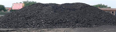
Mines, power plants, coal fields coal pile volume measurement
Smelters, chemical plants, cement raw material volume measurement
Food, feed and stacking ports volumetric measurement
Geological survey earthwork construction industry, rock profile analysis
Tunnel cross-section scanning and other objects from 3D scan |
|
|
|
|
| |
|
|
|


