|
%20-%20Leica%20Geosystems%20-%20Leica%20Geosystems.files/pix.gif) |
|
|
|
|
|
| 产品名: |
拓普康3D激光扫描仪 |
| 型 号: |
topcon
3D Laser Scanner GLS-1500 |
| 品 牌: |
日本拓普康 |
| 报 价: |
|
|
|
|
 |
| 产品简介 |
| |
- 高速扫描 3,0000点 /秒高采样率
- 拓普康精密扫描技术是扫描数据更少噪点
- 150m标称测距精度仅为4mm
- 一体化设计使扫描工作更便捷
- 采用 Jog Dial 控制系统的快速瞄准系统
- 内置数码相机
- ScanMaster 软件具有强大的数据处理功能
- 提供实景点云图像
- 通过无线系统可以进行遥控
|
| 产品特点 |
| |
|
|
|
|
|
扫描效率的大幅提高,可达30000点/秒
GLS-1500 采用每秒能发射30000次的激光元件,扫描速度是从前的十倍。
可以在很短时间内获得高精度点云数据,大大提高扫描效率。
|
|
|
|
|
|
|
独有拓普康精确扫描技术
超级降噪技术,刚精度, 高密度点云扫描,测距精度4mm@150m,测角精度(H&V)6秒
|
|
|
|
|
|
|
超低云噪点
扫描的最关键技术在于如何降低所获取数据的噪点,拓普康的高精度扫描技术
取得了超常的降噪效果, 这使被扫描的物体具有最好的质地效果。 |
|
|
|
|
|
|
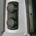
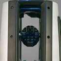
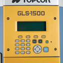
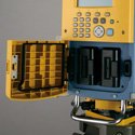
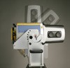
一体化,独立的扫描单元
友好,快速,易操作的操作不仅节约您的时间,而且提高了工作效率。电池面板,拓普康GLS-1500重量轻,无电缆.
集微动螺旋,扫描头,数码相机,SD 卡槽,显示屏及键盘于一体的拓普康GLS-1500. |
|
|
|
| |
|
|
|
|
|
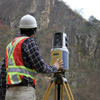
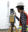
在任何地方使用GLS-1500,您都无需担心对路过的人造成眼睛损伤,因为1500使用的是不可见的,安全系数为1级的激光,这是对人眼安全的激光。在机场附近,在交通繁忙的街道,以及大都多数人烟密集的区域,并未给当地的人民或环境造成影响。
|
|
|
|
|
|
|
GLS-1500自动补偿器,使倾斜角度在±
6'以内,并使用内置的双轴倾斜传感器。这种能力提高了准确性,站点设置使用仪器点和后视数据。
|
|
|
|
|
|
|
In addition
to orientation using geo-referenced tie-point
targets, GLS-1500 can determine the coordinate
system using instrument point and backsight
data, thanks to the high accuracies in distance,
angles and tilt compensation. This capability
increases work efficiency by minimizing number
of targets needed for orientation.
|
|
|
|
|
|
Tilts
the GLS-1500 unit to scan upper and lower
portions of tunnels, buildings and other large
structures.
Maximum ±90° tilting range with 15° steps.
|
|
|
|
|
|
|
Rich
Functions with Intuitive User-interface!
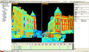
Multiple Viewer Window for Easy Data Alignment
Scan data captured from
multiple positions can be easily integrated
into one 3D data. Two or more point clouds
are shown on the computer screen at the
same time, facilitating data docking and
aligning procedures.
Supports most major data formats.
|
|
|
|
|
|
|
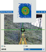
Target
scan is initiated either by manual aiming
or by clicking an image on a PC screen. The
ScanMaster automatically identifies the target
shape and calculates the target center coordinates.
|
|
|
|
|
|
|
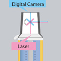
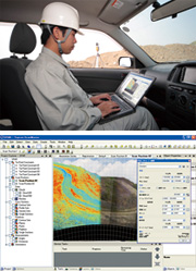
ScanMaster
controls the GLS-1500 scanner unit via wireless
LAN.
Scan area can be easily specified on video
or picture images on a computer screen. The
built-in digital camera takes a picture of
scan area on which scanned points are shown
in real-time, allowing you to check the status.
Pre-programming capability allows for automatic
multiple scans at one instrument position.
|
|
|
|
|
|
|
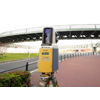
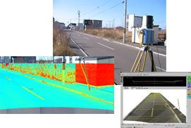
Road
Surface Profile
Measures Ruts and Bumps for Maintenance Purposes
GLS-1500 captures 3D road surface shapes with
exceptional ease and speed.
From roadside or other convenient locations,
GLS-1500 quickly scans the road surface without
an assistant on the road.
Highly accurate 3D road surface model facilitates
determination of repair locations as well
as volume calculation of pavement materials.
GLS-1500 dramatically increases work efficiency
and safety, and saves material costs. Traffic
congestion by blocking a lane is also eliminated.
|
|
|
|
|
|
|
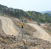
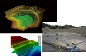
Volume
Measurement
Increases Safety, Efficiency and Accuracy
Volume measurement is indispensable for land
preparation, open-pit and underground mining,
waste landfills and sediment control facilities.
GLS-1500 allows the operators to take measurements
with an incomparable safety by eliminating
the need for working in the midst of heavy
machines.
High density point clouds allow for accurate
calculations of volume and geometry that no
other technology can offer. Example
in detail (Topcon At Work)
|
|
|
|
|
|
|
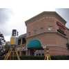
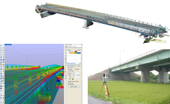
Large
Structure
Monitoring of Critical Infrastructures such
as Bridges, Towers, and Dams
Scan data of large structures allow for early
detection of deteriorated areas to be maintained
or reinforced. 3D data can be utilized for
measurements of size and geometry, as well
as volume calculations of necessary materials.
Periodic monitoring is one of the most effective
methods to prevent collapse of structures.
|
|
|
|
|
|
|
Disaster
and Accident
Detailed Survey with the Fastest Speed
3D terrain models can be easily created with
scan data. GLS-1500 acquires accurate and
detailed terrain data with exceptional speed
and safety.
GLS-1500 quickly scans disaster areas or accident
scenes. 3D models allows for computer simulations
of disasters and accidents.
|
|
|
|
|
|
|
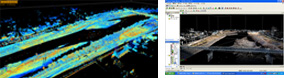
Flood
Control
Rivers, Dams, and Embankments
High density 3D point clouds can be utilized
for creating contour maps and profile drawings,
and for volume calculations. Simulation of
water flow paths greatly facilitates flood
control and disaster prevention planning.
|
|
|
|
|
|
|
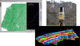
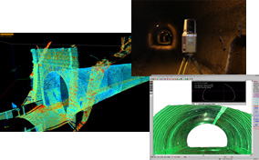
Tunnel
Profile Measurement and Convergence Monitoring
GLS-1500 captures 3D data of tunnel wall surfaces
in a short period of time. Even the most complex
surface profile can be modeled without difficulty.
Monitoring of wall convergence is an essential
measure to prevent collapse of tunnels both
under construction and in operation.
|
|
|
|
|
|
|
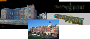
Historical
Architecture
Creation and Preservation of As-built Data
Full color, photorealistic 3D model will be
the most valuable record of historical architectures.
2D floor plans and cross-sectional drawings
can be easily created from 3D point clouds.
|
|
|
|
|
|
|
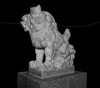
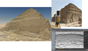
Archaeology
Photorealistic 3D Models of Ruins
Cutting-edge laser scanning technology realizes
preservation of valuable ruins in detailed
3D models.
GLS-1500 provides archaeologists with full
color, high resolution pictures that have
precise 3D coordinate values. Example
in detail (Topcon At Work)
|
|
| |
| 技术指标 |
|
扫描单元 |
|
最大扫描范围 |
|
|
90%
反射率 |
330m |
|
18%
反射率 |
150m |
|
最近扫描范围
|
1m |
|
单次测量点位精度 |
|
|
测距精度 |
4mm
at 1 to 150m |
|
测角精度(H&V)
|
6" |
|
分辨率 |
3"
at 50m (164ft.) |
|
扫描频率
|
30,000
points/second |
|
扫描分辨率 |
|
|
扫描光斑直径 |
<6mm
at 1 to 40m |
|
扫描间距 |
1mm
at 20m |
|
扫描范围 |
|
|
水平扫描角度范围 |
360°
(maximum) |
|
垂直扫描角度范围 |
±35°
(maximum) |
|
激光 |
|
|
激光类型 |
Pulsed
(time of flight) |
|
激光波长 |
1535nm
(invisible, eye-safe) |
|
激光等级 |
Class
1 |
|
数码相机 |
|
视场(水平/垂直)
|
Approx.
22° (V) x 16.5° (H) |
|
像素
|
2
megapixels |
|
补偿器 |
|
类型 |
双轴补偿 |
|
补偿范围 |
±6' |
|
显示 |
|
显示类型 |
LCD
with backlight, 20 characters x 4 lines |
|
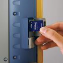
接口 |
|
存储 |
SD
and SDHC memory cards |
|
无线局域网
|
IEEE
802.11b |
|
USB |
Type
mini B Rev. 2.0 |
|
电源 |
|
可更换电池
(BT-65Q) |
5Ah,
7.4V |
|
工作时间 |
4
hours per 4 removable batteries |
|
输入电压 |
12V
DC |
|
工作环境 |
|
操作温度 |
0°C
to +40°C |
|
操作温度 |
-10°C
to +60°C |
|
防水防尘等级 |
IP52
(IEC 60529) |
|
物理指标 |
|
扫描仪外形尺寸(DxWxH) |
299
(D) x 240 (W) x 566 (H) mm |
|
扫描仪重量 |
16kg
(excluding battery and tribrach) |
|