|
|
%20-%20Leica%20Geosystems%20-%20Leica%20Geosystems.files/pix.gif) |
| |
|
|
|
| Product Name: |
AK36 High-precision UAV coal pan meter |
| Model: |
AK36 |
| Brand: |
BEIJING SAM SURVEYING |
| |
|
|
|
|
| Product Advantages: |
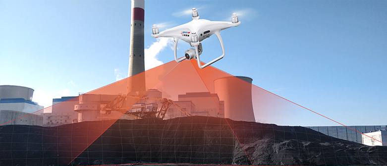
1) AK36 UAV coal panzer is a small multi-rotor high-precision UAV coal panzer.
2) with stronger anti-magnetic interference capability and accurate positioning ability.
3) Equipped with 1-inch 20-megapixel image sensor, wide-angle lens, supporting 4K video and high data quality.
4) with 10 km long-distance image transmission, safer and more secure without visual flight.
5) equipped with five-way environmental awareness function, reducing the risk of collision.
6) The whole set of equipment is light in weight and easy to carry. |
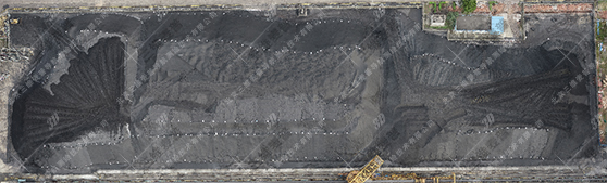
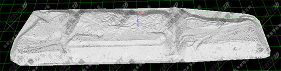
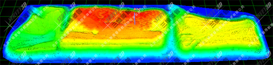
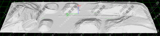
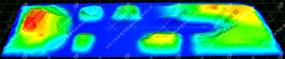
| UAV coal pan effect: |
| |
|
| |
|
| |
|
| |
|
| |
|
| |
| |
| Technical parameters: |
| |
|
| Product Type |
Professional-grade quadcopter |
| |
|
| Product weight |
1375g |
| |
|
| Flight radius |
0-6000m |
| |
|
| Hovering accuracy |
Vertical: ±0.1 m; Horizontal: ±0.3 m |
| |
|
| Flight Speed |
Sport mode: 72 km/h Attitude mode: 58 km/h Positioning mode: 50 km/h |
| |
|
| Wheelbase |
350mm |
| |
|
| Hover time |
About 30 minutes |
| |
|
| Withstand wind speed |
Level 6 |
| |
|
| Cloud Terrace |
3-axis head, stable accuracy ±0.02° |
| |
|
| Vision System |
Front View Vision System / Rear View Vision System / Down View Vision System |
| |
|
| Obstacle perception range |
0.7 - 30 m |
| |
|
| Camera |
Image sensor: 1-inch CMOS effective pixels: 20 million |
| |
|
| Vision sensing navigation system |
-20°C to 50°C |
| |
|
| Infrared sensing system |
Six-way infrared sensing system |
| |
|
| Display devices |
| |
|
| Operating equipment |
Tablet |
| |
|
| Processing equipment |
Portable Laptop |
| |
|
| Flight Control Software |
| |
|
| Smart Navigation |
The software is easy to operate, with intelligent navigation functions, the user can follow the prompts to operate the steps |
| |
|
| Route Planning |
Automatic route planning, automatic aerial photography and return |
| |
|
| One-touch take-off and landing |
One-touch take-off and landing function |
| |
|
| Real-time monitoring |
Real-time adjustment of heading |
| |
|
| Memory Storage |
System configuration and data saving, set up once for the same site |
| |
|
| Software Features |
|
| |
|
| Memory Storage |
Software running platform Windows 7 and above |
| |
|
| Calculation accuracy |
Fully automated high-precision 3D modeling, disc coal accuracy of 99.5% or more |
| |
|
| Intelligent noise reduction |
Ability to remove invalid data from outside the coal field area, ability to calculate volume and weight |
| |
|
| Partition Calculation |
Can realize the function of unified inventory, partition calculation volume, data editing function |
| |
|
| Three-dimensional view |
Display all coal field model drawings under one interface and support 3D dynamic browsing |
| |
|
| Color rendering |
Inclined ground measurement, coal pile 3D model map can be color elevation rendering, easy datum selection |
| |
|
| Intelligent processing |
Invisible foundation surface processing function: For the situation that the foundation surface is deeply buried under the coal pile, this function can be used to automatically process and eliminate the error |
| |
|
| Upgrade Extensions |
Software can be integrated with other laser counting devices for future upgrades and expansion to automatically generate standard format reports |
| |
|
| |