%20-%20Leica%20Geosystems%20-%20Leica%20Geosystems.files/pix.gif) |
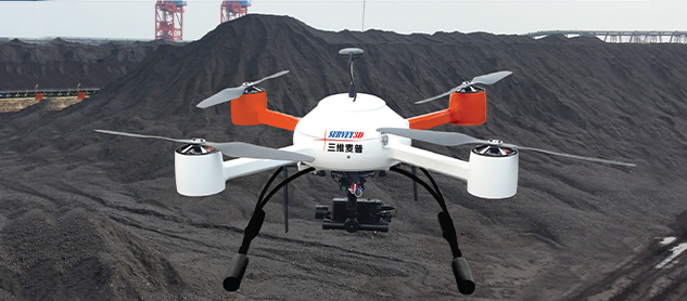
| UAV photographic sys |
| |
|
|
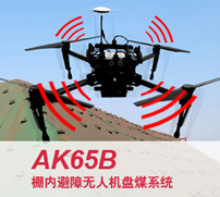
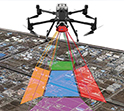
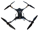
AK65B UAV in the shed |
|
automatic obstacle avoidance and autonomous flight for aerial photography of coal piles in arch sheds.
Automatic route planning, automatic aerial photography and return.
Fully automatic high-precision 3D modeling, with coal inventory accuracy of more than 99.5%.
|
|
|
|
|
|
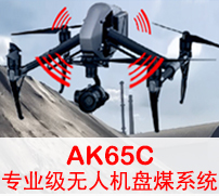
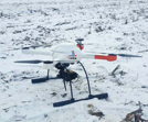
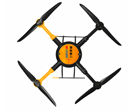
| AK65C UAV in the shed NEW |
|
automatic obstacle avoidance and autonomous flight for aerial photography of coal piles in arch sheds.
Automatic route planning, automatic aerial photography and return.
Fully automatic high-precision 3D modeling, with coal inventory accuracy of more than 99.5%.
|
|
|
|
|
|
| AK65D professional UAV NEW |
|
Automatic obstacle avoidance and autonomous flight, allowing for aerial inventory of coal piles in arched sheds.
Automatic route planning, automatic aerial photography and return.
Fully automatic high-precision 3D modeling, with coal inventory accuracy of more than 99.5%.
|
|
|
|
|
|
| AK65D-S Tilt UAS NEW |
|
automatic obstacle avoidance and autonomous flight for aerial photography of coal piles in arch sheds.
Automatic route planning, automatic aerial photography and return.
Fully automatic high-precision 3D modeling, with coal inventory accuracy of more than 99.5%.
|
|
|
|
|
|
| AK36 High-precision UAV coal pan meter NEW |
|
AK36 UAV coal panzer is a small multi-rotor high precision UAV coal panzer.
Having stronger anti-magnetic interference capability and accurate positioning ability.
Equipped with 1 inch 20 megapixel image sensor, wide angle lens, support 4K video and high data quality. |
|
|
|
|
|
| AK36R RTK cm-level UAV coal panzer NEW |
|
Integration of the new RTK module, with stronger anti-magnetic interference capability and accurate positioning ability.
Providing real-time centimeter-level positioning data, significantly improving the accuracy of the data.
The device's clock system of flight control, camera and RTK is synchronized at microsecond level, and the camera imaging moment has millisecond-level error.
|
|
|
|
|
|
| Hummingbird Disc Coal Quadcopter UAS-AK72 |
Hummingbird AK72 UAV flight attitude accuracy when aerial photography pan coal, low noise, anti-voltage line electromagnetic interference, performance for the domestic surveying and mapping industry professional grade quadcopter higher level, in the pan coal industry is a better UAV pan coal system. |
|
|
|
|
|
|
Hummingbird Micro Quadcopter UAS - AK65 |
|
Hummingbird AK65 UAV disk coal system, using a closed integrated carbon fiber fuselage structure, beautiful appearance, dustproof and waterproof, light weight fuselage, equipped with high-performance aviation motors and batteries; to adapt to the requirements of high-precision aerial photography disk coal, the 15-inch large propeller used, low-speed operation, can extend the flight time, increase the aircraft attitude stability, large load capacity, can reach 1 kg.
|
|
|
|
|
|
| Hummingbird Micro Quadcopter UAS-AK68
|
|
AK-68 type foldable UAV frame design, high-strength carbon fiber fuselage, the landing gear is lightweight, manually removable, and easy to operate software. |
|
|
|
|
|
| Hummingbird Micro Quadcopter UAS - AK1000 |
|
The AK1000 is an electric UAV customized for its miniature tilt camera, which provides the flexibility to perform high-resolution aerial photography missions with the tilt camera on board, while ensuring the safety of the device.
|
|
|
|
|
|
|
Water scale observation program with waterproof drones
|
The water scale observation program of hanging waterproof UAV is to use the UAV system as the task carrier, with the steady image gimbal, video system, and the plumb suspension system, to realize putting down the UAV on the side of the ship, through the display screen held by the personnel on board, real-time observation of the water scale, and video storage at the same time, so that it is easy to check when there is a dispute. The product can prevent seawater erosion. |
|
|
|
|
|
| Quadrotor UAS-microdrones
md4-1000 |
|
md4-1000The quadrotor UAS is a vertical takeoff and landing small autopilot unmanned aerial vehicle system that can be used to perform a variety of aerial tasks such as reconnaissance, photography, mapping, detection, command, search, communication and airdrop. |
|
|
|
|
|
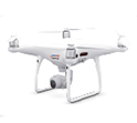
| Retrofit DJI Drone Genie 3Phantom
3 |
|
As we all know, DJI drones belong to foolish models, taking photos will not only have spherical distortion, but also poor resolution and accuracy, we can modify DJI's drones and add Sony's micro-single camera.
|
|
|
|
| |
| |
| |
|