|
|
 |
| |
%20-%20Leica%20Geosystems%20-%20Leica%20Geosystems.files/pix.gif) |
| |
|
|
|
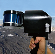
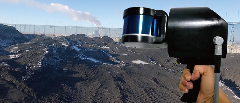
| 产品名: |
M360 Automatic 3D laser scanner |
| 型 号: |
M360 |
| 品 牌: |
|
| 报 价: |
|
|
|
|
| Products |
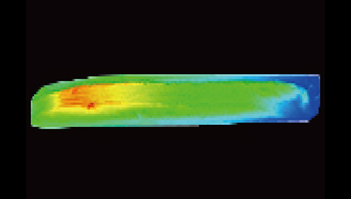
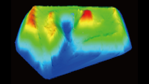
1、Adopt synchronous positioning and composition way of measurement, easy to use, ten minutes to get started, walking around the coal pile for a few minutes to become a map.
2、Adopt the international common radar 360°rotation mode design, can carry out zenith and ground full field of view scanning, the performance is better than cheap fixed radar scanning, the image has no blind area, not easy to lose lock.
3, the main body of the device weighs 2.4kg, can scan 300,000 points per second, scanning radius up to 160 meters, measurement accuracy less than 3 cm, volume error better than five thousandths.
4、 It can be handheld, vehicle-mounted, ship-mounted or unmanned aircraft-mounted, and if it is suspended on the rail trolley, it can scan the 200m-long pile in only 5 minutes, and it can be used before, during and after the coal shed construction stage.
5、 Measurement data graphics can be viewed on cell phone or computer in real time, also wireless real-time data return, automatic noise reduction processing can be done on the computer side, one key to report.
6, no GPS signal, no need to lay control points in advance, walk a circle back to the starting point to complete the measurement.
7, can be fixed installation, set to slow precision scanning mode, to achieve 2 seconds high precision scanning, can be silo, oil tanks, ship bunker, coal shed and other closed space scanning.
8, optional target ball for data conversion of the coordinate system, optional backpack support to release hands, walking more safely, optional stabilization platform to reduce the impact of vibration on the scanner。
|
| |
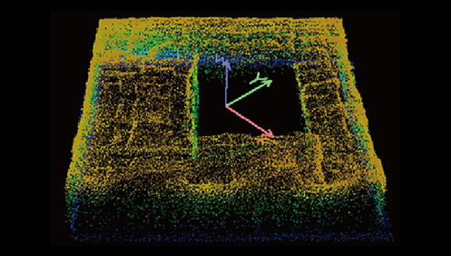
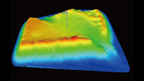
| Measurement method |
|
|
|
|
|
|
| The black and white rendering is as follows:
|
| Technical parameters |
Measurement Program |
160m |
| Point picking rate |
300,000 points/second |
Travel speed |
Less than 8 meters per second |
| Vertical Range |
0.08° |
Horizontal angle accuracy |
-90°to+90° |
| Horizontal Range |
360°No blind spot in all directions |
| Scanning accuracy |
<3cm |
| Operating temperature |
-30~+60 |
| Working humidity |
95%, non-condensing |
| Scanning frequency |
10Hz |
| IP Rating |
IP67 waterproof and dustproof |
| Instrument weight |
2.4kg |
| Body Size |
120×180×232mm |
| Laser grade |
Class 1 human eye safety laser |
| Laser wavelength |
905nm |
| Battery Type |
12V lithium electronic battery |
| Communication Interface |
LEMOPlug |
| Working hours |
Can work continuously for 4 hours |
| Main control parameters |
| Memory Capacity |
256G |
Data Interface |
USB |
Battery Capacity |
8AhRechargeable lithium battery |
Software Features |
Data Processing |
Real-time data processing |
Noise removal |
Automatic noise reduction |
| Reporting Method |
One-click reporting for any stacked terrain |
| Coordinate conversion |
Coordinate conversion using 3 points |
| Data Format |
Exportable to many common data formats such as ASC |
| Point cloud display |
Two-dimensional and three-dimensional color graphics display |
| |
|
|
| |
| Applications |
It works normally in various complex and harsh environments such as heap, underground space, forestry industry, building measurement, ancient building measurement, etc. It can be scanned handheld and can be deployed quickly to work in a variety of complex environments, and has a 360° scanning field of view, faster and more accurate scanning, and higher quality of the acquired point cloud data. Thanks to the automatic rotation of the scanner, the M360 handheld laser scanner can be used in a variety of measurement methods, for all terrain and all directions can be accurately measured every location of the building. With the lightweight body and quick operation mode, the M360 can quickly complete the measurement of ancient buildings to fill in the points. |
| |
| |
|
|